u
usmanali_kakar

Usman Ali

@usmanali_kakar
5.0(2)

Remote sensing and GIS analyst

Pakistán
Inglés
Parte de la información aparece en idioma inglés.
Sobre mí
Hello! I am Usman Ali, I have extensive experience in remote sensing and GIS. I am an Esri certified GIS analyst with more than 5 years of field & industrial experience in GIS & remote sensing. I can perform a wide range of Geospatial analyses. Moreover, I can provide you interactive maps, Geodatabases, Data Cleaning, Data Analysis and visualization, HotSpot Analysis Site Suitability Analysis, Image classification and segmentation, Landuse and Land classification maps, modeling, temporal analyses, and Spectral Indices (NDVI, NDWI, etc.). Satisfaction & perfection are my priorities.... Lee más

Habilidades

u
usmanali_kakar
Usman Ali
desconectado • 
Tiempo medio de respuesta: 1 hora

Revisa mis servicios

Sistemas de información geográfica (GIS)
I will create maps with arcmap, arc pro, qgis, erdas imagine
5.0(2)
Sistemas de información geográfica (GIS)
I will do programming, mapping and analysis

Porfolio

Experiencia laboral

Lead RS and GIS

DEBSA • Freelance

Jul 2023 - Dec 20241 yr 5 mos

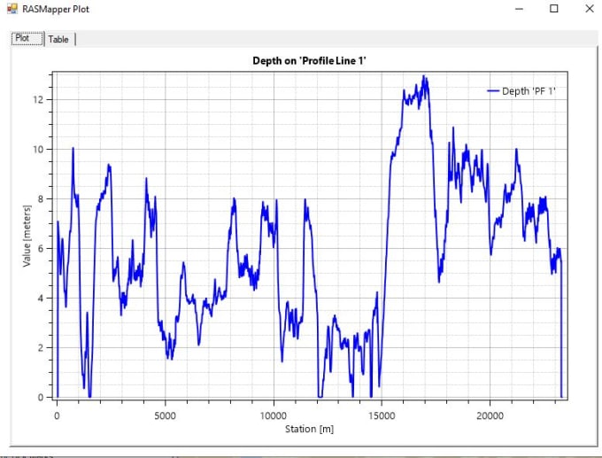
Hydrological analysis, GIS and remote sensing

2 Reseñas
5.0

(2)
(0)
(0)
(0)
(0)
Desglose de calificaciones
  • Nivel de comunicación del Freelancer
    5
  • Calidad de la entrega
    5
  • Valor de la entrega
    5
1-2 de 2 reseñas
Ordenar por
Más relevante
    H

    harris_95

    GB

    Reino Unido

    5

    Highly recommended! Usman is a hard-working, committed, determined, and firm professional. I will surely do another project with him since he showed outstanding reliability on the first job, delivered it on time, and exceeded my expectations in terms of work quality.

    Hasta USD50

    Precio

    3 días

    Tiempo

    gig

    Sistemas de información geográfica (GIS)

    Útil?
    No
    N

    noufff1107

    Cliente recurrente

    AE

    Emiratos Árabes Unidos

    5

    Very professional..and never took too long to reply or deliver the work. Highly recommended

    Hasta USD50

    Precio

    4 días

    Tiempo

    gig

    Sistemas de información geográfica (GIS)

    Útil?
    No