Explorar las categorías
Explora
Fiverr Pro
Español
$
USD

Traducción automática
Trabajarás con un especialista en LiDAR que comprende todo el flujo de trabajo, desde la adquisición de datos en campo hasta el procesamiento y análisis profesional.
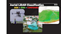
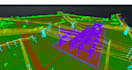
He completado más de 1,000 proyectos de clasificación LiDAR y modelado de terrenos en Upwork, incluyendo conjuntos de datos aéreos LiDAR y de mapeo móvil, con más de 6,000 horas de experiencia práctica. Mi especialización se centra en una clasificación precisa de suelo / no suelo, generación de DEM, DTM y líneas de contorno para proyectos de topografía, ingeniería e infraestructura.
Además del procesamiento de datos, soy un piloto de UAV con experiencia, operando plataformas profesionales de LiDAR y fotogrametría como DJI Matrice 300 RTK, Matrice 350 RTK con Zenmuse L1/L2, Matrice 3E/4E/3T, Phantom 4 RTK, Stormbee UAV S20 con escáner FARO y senseFly eBee Plus. Esta experiencia en campo me permite entender completamente la calidad de los datos, las limitaciones de los sensores y las condiciones reales de la encuesta.
Los clientes me eligen por entregables limpios y confiables, control de calidad estricto, rapidez en la entrega y comunicación técnica clara. Mi objetivo es entregar productos LiDAR precisos y optimizados, listos para su uso inmediato en flujos de trabajo CAD, GIS e ingeniería.
Estaré encantado de apoyar tu proyecto
Geomatics Expert
Idiomas
Traducción automática
Traducción automática
1. ¿Qué formatos de datos aceptas?
Acepto LAS, LAZ, E57, PTS, XYZ, RCP y otros formatos comunes de nubes de puntos LiDAR.
¿Puedes hacer clasificación de suelo / no suelo?
Sí. Proporciono clasificación precisa de suelo y no suelo usando software profesional de GIS y LiDAR.
¿Proporcionas DTM y DEM?
Sí. El DTM y el DEM se generan después de una clasificación adecuada del suelo.
¿Qué intervalos de contorno puedes entregar?
Cualquier intervalo que necesites (por ejemplo, 0.5 m, 1 m, 2 m). Por favor, especifica antes de comenzar.
¿Este servicio es adecuado para datos LiDAR de UAV?
Sí. Procesamos tanto datos LiDAR de UAV como terrestres/móviles.
¿Cuál es el formato de salida?
DTM/DEM: GeoTIFF o ASC Contornos: DWG, DXF, SHP o PDF
¿Qué tan precisos son los resultados?
La precisión depende de la calidad de los datos de entrada, pero siempre busco resultados de alta precisión, de nivel de encuesta.
¿Puedes manejar conjuntos de datos grandes?
Sí. Tengo experiencia procesando conjuntos de datos LiDAR muy grandes (de decenas a cientos de GB).
¿Sigues algún estándar o flujo de trabajo?
Sí. Sigo flujos de trabajo estándar de LiDAR y GIS comúnmente utilizados en proyectos de topografía y mapeo.
10. ¿Puedes revisar mis datos antes de hacer el pedido?
Por supuesto. Puedes enviar una muestra o detalles, y los revisaré antes de que hagas un pedido.


