Explorar las categorías
Explora
Fiverr Pro
Español
$
USD

Traducción automática
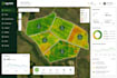
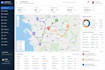
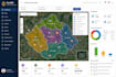
Desarrolla una aplicación personalizada de mapeo web GIS para tu negocio
¿Buscas un desarrollador profesional de GIS para crear una aplicación de mapeo web potente e interactiva adaptada a las necesidades de tu negocio? ¡Estás en el lugar correcto!
Me especializo en diseñar y desarrollar aplicaciones web GIS personalizadas que transforman datos espaciales en mapas y paneles interactivos e intuitivos. Ya sea en bienes raíces, logística, gestión ambiental, planificación urbana, agricultura o gestión de activos, puedo crear una solución que te ayude a visualizar, analizar y gestionar datos basados en la ubicación de manera eficiente.
Lo que ofrezco
Por favor, envía un DM antes de hacer tu pedido!
Recuerda que incluir temas, plantillas o cualquier otro elemento que viole los derechos de terceros o las leyes aplicables en los trabajos entregados va en contra de las políticas de Fiverr. Puedes ver más información en Guía para la creación digital responsable.
Oscar Dev
Idiomas
Traducción automática
Traducción automática
¿Qué información necesitas para empezar?
Por favor, proporciona una descripción detallada de tu proyecto, tus datos GIS (si los tienes), las funciones de mapa preferidas, requisitos de diseño y cualquier ejemplo de referencia. Si aún no tienes datos GIS, puedo ayudarte a determinar la mejor estrategia.
¿Qué formatos de datos GIS soportas?
Trabajo con una amplia variedad de formatos de datos geoespaciales, incluyendo Shapefile (SHP), GeoJSON, KML/KMZ, GPX, CSV, GeoPackage, PostGIS y otros conjuntos de datos GIS comunes.
¿Qué tecnologías de mapeo utilizas?
Dependiendo de los requisitos de tu proyecto, desarrollo aplicaciones usando Leaflet, Mapbox GL JS, OpenLayers, APIs de ArcGIS, PostGIS, GeoServer, React, JavaScript, Node.js y Python.
¿Puedes crear una aplicación GIS para mi industria?
Sí. Desarrollo soluciones GIS personalizadas para bienes raíces, logística, transporte, gestión ambiental, agricultura, servicios públicos, gobierno, planificación urbana, construcción, turismo y muchas otras industrias.
¿Mi mapa web funcionará en dispositivos móviles?
Por supuesto. Cada aplicación web GIS está diseñada para ser adaptable y funcionar sin problemas en escritorios, tablets y dispositivos móviles.
¿Puedes integrar APIs externas o bases de datos?
Sí. Puedo integrar REST APIs, servicios de Google Maps, PostGIS, PostgreSQL, GeoServer y otros servicios de terceros según los requisitos de tu proyecto.
¿Proporcionas el código fuente?
Sí. Recibirás código fuente limpio y bien documentado como parte del proyecto finalizado, a menos que se acuerde lo contrario antes de comenzar el desarrollo.


