Explorar las categorías
Explora
Fiverr Pro
Español
$
USD


Traducción automática
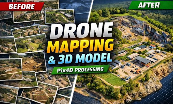
¿Tienes imágenes de drone listas pero no sabes cómo convertirlas en mapas precisos y modelos 3D?
Ya sea que estés trabajando en un proyecto de construcción, levantamiento topográfico, agricultura, minería o desarrollo de infraestructura, puedo transformar tus imágenes aéreas en entregables geoespaciales profesionales usando Pix4D.
Me especializo en procesar imágenes de drone en mapas ortomosaicos, mapas 3D, modelos digitales de terreno (DTM), modelos digitales de superficie (DSM), nubes de puntos, mapas de contorno y cálculos de volumen con precisión y atención al detalle. Cada proyecto se procesa siguiendo flujos de trabajo estándar de la industria para ofrecer resultados confiables para aplicaciones GIS, CAD, BIM y de ingeniería.
Lo que recibirás:
Ya seas topógrafo, ingeniero, arquitecto, contratista, investigador o operador de drone, estoy comprometido a entregarte resultados precisos y profesionales que te ayuden a tomar decisiones confiadas.
Envíame tus imágenes de drone y detalles del proyecto antes de hacer tu pedido, y te recomendaré el mejor flujo de trabajo para tu proyecto.
Informa al freelancer cualquier preferencia o inquietud que tengas con respecto al uso de herramientas de IA en la finalización y/o entrega de tu pedido.
3d cad modelling specialist
Idiomas
Traducción automática
Traducción automática
1. ¿Qué archivos necesito proporcionar?
Sube tus imágenes de drone en formato JPG, JPEG, PNG o RAW. Si tienes, incluye información de GPS/geotag para mayor precisión.
¿Qué software utilizas?
Utilizo Pix4D para procesar las imágenes aéreas y obtener entregables precisos de mapas y reconstrucción en 3D.
3. ¿Qué entregables puedo recibir?
Dependiendo de tu paquete, puedes recibir: Mapas ortomosaicos Modelos 3D DTM DSM Nubes de puntos Mapas de contorno Cálculos de volumen
4. ¿Puedes procesar grandes conjuntos de datos de drone?
Sí. Si tu proyecto tiene más de 500 imágenes, contáctame para una oferta personalizada.
5. ¿Necesito contactarte antes de hacer el pedido?
Sí. Por favor, envíame un mensaje primero para que pueda revisar tu proyecto, la calidad de las imágenes y los requisitos antes de que hagas un pedido.