Explorar las categorías
Explora
Fiverr Pro
Español
$
USD

Habilidades
Revisa mis servicios
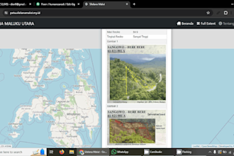
WebGIS of Road Network in North Maluku Province
SinauGIS • Freelance
Nov 2023 - Dec 2024 • 1 yr 1 mo
Challenge: The Provincial Government of North Maluku required a digital transformation of their road infrastructure data. They needed an interactive spatial system to visualize the condition, length, and surface type of road networks across the province to aid in maintenance planning. Solution: I designed and deployed a comprehensive WebGIS Application specifically for road network management. Using Leaflet JS for the frontend and QGIS for spatial data processing, I converted complex road datasets into an accessible web map. Key Features: Thematic Road Mapping: Color-coded polylines distinguishing road status (Good, Moderate, Heavily Damaged). Interactive Attributes: Users can click on any road segment to view details like Road Name, Authority, Width, and Surface Material (Asphalt/Concrete). Smart Filtering: A search feature to quickly locate specific road sections within the province. Responsive UI: Optimized for access via desktop and mobile tablets for field surveyors. Outcome: The system successfully digitized the road asset data, allowing stakeholders to identify critical infrastructure needs quickly without relying on manual paper maps.
