Explorar las categorías
Explora
Fiverr Pro
Español
$
USD
Level 2


Traducción automática
Soy un experto en GIS con más de 20 años de experiencia en la industria en mapeo GIS, análisis de tierra, geobases de datos, teledetección, cartografía, visualización de datos geoespaciales y aplicaciones interactivas de WebGIS.
Ofrezco un conjunto completo de servicios relacionados con Sistemas de Información Geográfica, diseño de mapas, análisis de mapeo de tierra, digitalización de datos vectoriales y ráster a escala en capas, almacenamiento de datos geográficos en geobases de datos, conversión de coordenadas, cartografía, topografía, levantamiento topográfico, modelador, DEM, mapeo con drones y procesamiento de imágenes satelitales usando los últimos programas como ArcGIS Pro, ArcMap, QGIS, Global Mapper, Erdas Imagine, Google Maps y Google Earth.
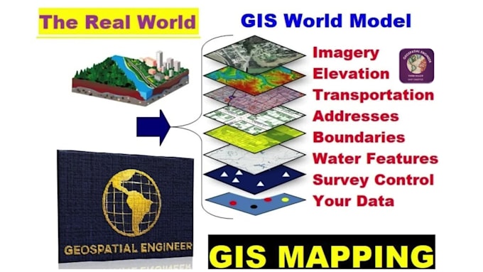
Puedo crear mapas GIS impresionantes que muestran datos geográficos con características, límites de lotes, lugares y ubicaciones (latitud, longitud, GPX, KML, shapefile, dirección o código postal). Puedo diseñar mapas personalizados para satisfacer tus necesidades específicas, ya sea Catastral, Topográfico, Batimétrico, Temático, Climático, de Carreteras, de Parcelas o de Propiedades.
Mis servicios profesionales de mapeo GIS, análisis geoespacial y mapeo web te ayudarán a gestionar mejor tus proyectos y tomar decisiones más acertadas. ¿Entonces, por qué esperar? Comencemos a trabajar en tu proyecto de inmediato.
CONTACTA ANTES DE HACER EL PEDIDO
Pro Experts in GIS, Mapping, 3D Models, Drones, and Civil Engineering
Level 2
Idiomas
Traducción automática
Traducción automática
¿Qué servicios ofrece usted como experto en SIG?
Ofrezco una amplia gama de servicios que incluyen mapeo SIG, análisis espacial, cartografía, gestión de geodatabases, consultas geoespaciales y desarrollo de aplicaciones de mapas SIG web interactivos.
¿Qué es el mapeo SIG?
La cartografía mediante SIG es el proceso de creación de mapas digitales que muestran información geográfica, como ubicaciones, límites y características. Esta información se puede utilizar para comprender patrones y relaciones espaciales, lo que puede resultar valioso para diversos fines.
¿Qué tipos de mapas puedes crear?
Puedo crear mapas ArcGIS impresionantes que muestran datos geográficos con características, límites, lugares y ubicaciones con latitud/longitud, GPX, KML, Shapefile, dirección o código postal. Me especializo en mapas personalizados adaptados a necesidades específicas, incluidos mapas catastrales, topográficos, batimétricos, de propiedades y más.
¿Qué software utiliza para proyectos SIG?
Utilizo el software más reciente, como ArcGIS Pro, ArcMap, QGIS, Global Mapper, Google Maps y Google Earth Pro para mapeo SIG, análisis espacial y visualización.
¿En qué aspectos destaca el SIG?
Los SIG integran muchos tipos diferentes de capas de datos utilizando información espacial. Los datos tienen un componente geográfico. Los datos SIG incluyen mapas, imágenes satelitales, imágenes de drones o vehículos aéreos no tripulados, características y mapas base vinculados a hojas de cálculo y tablas.
¿Qué es la digitalización en SIG?
La digitalización en SIG se refiere al proceso de convertir datos geográficos analógicos, como mapas, imágenes satelitales o fotografías aéreas, en formatos digitales que se pueden manipular, analizar, modelar y almacenar dentro de un Sistema de Información Geográfica (SIG).
¿En qué tipo de proyectos te especializas?
Con más de 15 años de experiencia en la industria, me especializo en una amplia variedad de proyectos SIG, incluidos diseños de mapas, visualización cartográfica, digitalización de datos vectoriales y raster, almacenamiento de geodatos, análisis geoespacial, conversión de coordenadas, teledetección y topografía.
¿Cómo pueden sus servicios beneficiar mi proyecto?
Mis servicios profesionales de mapeo SIG, análisis espacial y mapas SIG web pueden mejorar significativamente la gestión de proyectos y los procesos de toma de decisiones al proporcionar información valiosa y visualizaciones de datos geográficos.
¿Necesito comunicarme con usted antes de realizar un pedido?
Sí, animo a los compradores a que se pongan en contacto conmigo antes de realizar un pedido para analizar los requisitos del proyecto, el alcance y cualquier detalle específico para garantizar una colaboración fluida y exitosa.
| (10) | ||
| (0) | ||
| (0) | ||
| (0) | ||
| (0) |
jasonwarner845
Cliente recurrente

Costa Rica
Thank you once again.
USD50-USD100
Precio
4 días
Tiempo
jasonwarner845
Cliente recurrente
Costa Rica
Thank you once again.
Hasta USD50
Precio
6 días
Tiempo
ricmed372
Cliente recurrente

Estados Unidos
Thank you. I appreciate the work
USD100-USD200
Precio
5 días
Tiempo

jasonwarner845
Cliente recurrente
Costa Rica
Thank you once again. Nice work.
USD100-USD200
Precio
10 días
Tiempo
jasonwarner845
Cliente recurrente
Costa Rica
Visually appealing and technical excellence. Mr. Geospatial does great work. Clear and responsive communication. Will look for other opportunities to partner.
USD100-USD200
Precio
4 semanas
Tiempo
| (10) | ||
| (0) | ||
| (0) | ||
| (0) | ||
| (0) |
jasonwarner845
Cliente recurrente
Costa Rica
Thank you once again.
USD50-USD100
Precio
4 días
Tiempo
jasonwarner845
Cliente recurrente
Costa Rica
Thank you once again.
Hasta USD50
Precio
6 días
Tiempo
ricmed372
Cliente recurrente
Estados Unidos
Thank you. I appreciate the work
USD100-USD200
Precio
5 días
Tiempo
jasonwarner845
Cliente recurrente
Costa Rica
Thank you once again. Nice work.
USD100-USD200
Precio
10 días
Tiempo
jasonwarner845
Cliente recurrente
Costa Rica
Visually appealing and technical excellence. Mr. Geospatial does great work. Clear and responsive communication. Will look for other opportunities to partner.
USD100-USD200
Precio
4 semanas
Tiempo