Explorar las categorías
Explora
Fiverr Pro
Español
$
USD
Level 1


Traducción automática
Soy un ingeniero geoespacial (Maestría) con más de 15 años de experiencia creando modelos digitales de elevación, mapas de contorno, soluciones GIS, LiDAR y levantamientos topográficos. Ayudo a ingenieros, consultores, investigadores y desarrolladores de terrenos a convertir datos de elevación en modelos de superficie precisos y listos para la toma de decisiones.
Este servicio incluye:
Entregables principales
Servicios adicionales
Entrego en el formato de archivo y resolución que se adapte a tu software. Solo dime qué programa usas y ajustaré los archivos en consecuencia.
Herramientas que utilizo: ArcGIS Pro, QGIS, Google Earth, Global Mapper, Pix4D, Metashape, AutoCAD Civil 3D
Confiado por clientes recurrentes en todo el mundo.
Envíame un mensaje con tu fuente de datos y área del proyecto (dirección, coordenadas o pin de Google Maps), y confirmaré el alcance, los entregables y el tiempo de entrega antes de que hagas tu pedido.
GIS Mapping, Drone Surveying, CAD Site Plans, 3D Modeling and Animations
Level 1
Idiomas
Traducción automática
Traducción automática
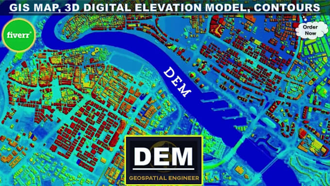
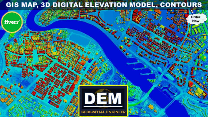
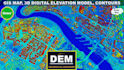
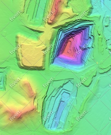
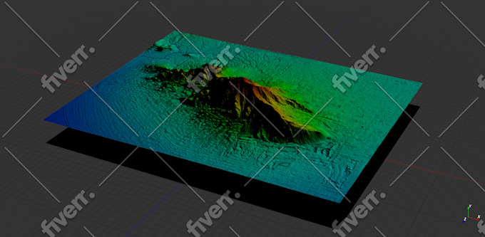
¿Qué es un Modelo de Elevación Digital (DEM)?
Un modelo de elevación digital (DEM) es una representación gráfica por computadora en 3D de datos de elevación para representar el terreno. DEM es una capa SIG rasterizada con cuadrículas rasterizadas de la superficie de la Tierra referenciadas al datum vertical (elevación cero).
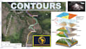
¿Qué son las curvas de nivel y los mapas topográficos?
En pocas palabras, las curvas de nivel marcan puntos de igual elevación en un mapa. La topografía es el estudio de las características geográficas de un paisaje. Un mapa con líneas de contorno se llama mapa topográfico. Básicamente, los mapas topográficos representan el paisaje tridimensional de la Tierra dentro del espacio 2D de un mapa.
¿Qué datos se necesitan para crear un DEM y un mapa de contorno?
Para crear un DEM y un mapa de contorno, normalmente necesito datos de elevación de fuentes como topografía topográfica o estudios terrestres (GNSS, DGPS, estación total, escáner láser, LiDAR), imágenes estéreo fotogramétricas (imágenes satelitales, fotografías aéreas), SAR, Conjuntos de datos radar u hojas topográficas.
¿Pueden personalizar los intervalos de las curvas de nivel y las especificaciones del mapa según mis requisitos?
¡Absolutamente! Entiendo que diferentes proyectos pueden tener requisitos únicos. Ya sea que necesite intervalos de curvas de nivel específicos, extensiones de mapas, sistemas de coordenadas u otras especificaciones, puedo adaptar los entregables para satisfacer sus necesidades exactas.
¿Qué tipos de proyectos pueden beneficiarse de sus servicios?
Mis servicios son ideales para una amplia gama de proyectos, incluido el desarrollo territorial, el diseño de ingeniería, el modelado de cuencas hidrográficas, la planificación de sitios, el análisis climático y más. Ya sea que sea una empresa de ingeniería o un consultor ambiental, puedo ayudarlo con sus necesidades de mapeo de contornos GIS y DEM.
¿Cuáles son las aplicaciones extendidas de los modelos digitales de elevación?
- Sistemas de información geográfica/cartografía SIG - Topografía terrestre y contornos topográficos - Visualización 3D - Ingeniería civil - Hidrología/modelado hidrológico - Modelos y cartografía de inundaciones - Carreteras/Ingeniería ambiental/de recursos hídricos - Telecomunicaciones y servicios públicos
¿Qué software utiliza para desarrollar DEM y mapas de contorno?
Me especializo en el uso de ArcGIS Pro, un software SIG profesional, para desarrollar DEM y mapas de curvas de nivel de alta calidad. ArcGIS Pro ofrece capacidades avanzadas para el análisis y visualización del terreno, lo que garantiza resultados precisos y detallados.
¿Cuál es el tiempo de respuesta típico para entregar el producto final?
El tiempo de respuesta puede variar según la complejidad y el alcance del proyecto. Al analizar sus requisitos, le proporcionaré un cronograma de entrega estimado. Tenga la seguridad de que me esfuerzo por ofrecer resultados de alta calidad de manera oportuna para cumplir con los plazos de su proyecto.
¿Ofrecen revisiones si no estoy satisfecho con los resultados iniciales?
Sí, la satisfacción del cliente es primordial para mí. Ofrezco revisiones para garantizar que los entregables finales cumplan con sus expectativas y requisitos del proyecto.
| (15) | ||
| (1) | ||
| (0) | ||
| (0) | ||
| (0) |
bleblanc03

Estados Unidos
Great to work with. Delivered nice assets for my project. I would not hesitate to reach out again if/when I need more work at this level.
USD400-USD600
$
3 semanas
Tiempo
jebjeb2000
Estados Unidos
I needed a model of a mountain for architectural rendering. Geospatial provided a highly detailed file that was actually far too large for my program to handle. Geospatial followed up with several options of smaller size, and I was able to use the edits. They were communicative in adjusting the parameters to fit what I needed. Thank you!
USD100-USD200
$
2 semanas
Tiempo

Respuesta del Freelancer
ricmed372
Cliente recurrente
Estados Unidos
Thank you. I appreciate the work
USD100-USD200
$
5 días
Tiempo

jasonwarner845
Cliente recurrente

Costa Rica
This is my third order with Geospatial. Always high quality, timely, and visually appealing.
Hasta USD50
$
1 día
Tiempo
jasonwarner845
Cliente recurrente
Costa Rica
This is my second project with Geospatial Engr. I found them after an underwhelming experience with another provider. Very pleased with the technical capabilities and professional way they presented the data. When the need arises, I would be happy to work with Geospatial again.
USD100-USD200
$
8 días
Tiempo
| (15) | ||
| (1) | ||
| (0) | ||
| (0) | ||
| (0) |
bleblanc03
Estados Unidos
Great to work with. Delivered nice assets for my project. I would not hesitate to reach out again if/when I need more work at this level.
USD400-USD600
$
3 semanas
Tiempo
jebjeb2000
Estados Unidos
I needed a model of a mountain for architectural rendering. Geospatial provided a highly detailed file that was actually far too large for my program to handle. Geospatial followed up with several options of smaller size, and I was able to use the edits. They were communicative in adjusting the parameters to fit what I needed. Thank you!
USD100-USD200
$
2 semanas
Tiempo
Respuesta del Freelancer
ricmed372
Cliente recurrente
Estados Unidos
Thank you. I appreciate the work
USD100-USD200
$
5 días
Tiempo
jasonwarner845
Cliente recurrente
Costa Rica
This is my third order with Geospatial. Always high quality, timely, and visually appealing.
Hasta USD50
$
1 día
Tiempo
jasonwarner845
Cliente recurrente
Costa Rica
This is my second project with Geospatial Engr. I found them after an underwhelming experience with another provider. Very pleased with the technical capabilities and professional way they presented the data. When the need arises, I would be happy to work with Geospatial again.
USD100-USD200
$
8 días
Tiempo