Explorar las categorías
Explora
Fiverr Pro
Español
$
USD

Level 1
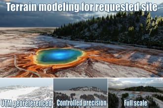
geospatial enginner
Habilidades
Revisa mis servicios

¿Quieres trabajar por horas?
Dile a Miguel qué necesitas.
USD 65
/
hora| (29) | ||
| (0) | ||
| (0) | ||
| (0) | ||
| (0) |
jbeck1116

Estados Unidos
great work, thank you
USD100-USD200
$
3 días
Tiempo

lshapir8
Estados Unidos
metawijnen
Cliente recurrente

Croacia

ezmacc
Estados Unidos
Miguel truly shines in landscape design! His professionalism and ATTENTION TO DETAILS exceeded my expectations, while his quick responsiveness and language fluency made working together a breeze. 🙌 Highly recommend!
robaatoo

Alemania
Quick and great wokr! Fast response and friendly contact!