Explorar las categorías
Explora
Fiverr Pro
Español
$
USD


Traducción automática
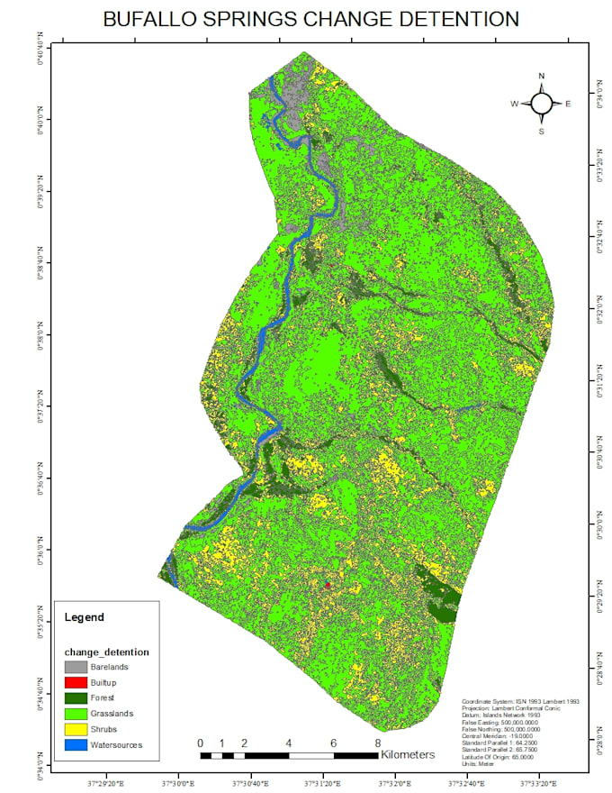
¿Buscas un análisis detallado y preciso de uso de suelo y cobertura terrestre (LULC)? Me especializo en mapeo y detección de cambios a lo largo del tiempo usando plataformas de vanguardia como ArcMap, ArcGIS Pro, Python, Google Earth Engine (GEE) y técnicas de aprendizaje automático. Mis servicios incluyen identificar diferentes clases de cobertura terrestre (por ejemplo, vegetación, áreas urbanas, cuerpos de agua, tierras agrícolas) y analizar cambios temporales usando imágenes satelitales como Landsat, Sentinel y conjuntos de datos comerciales de alta resolución. Con experiencia en clasificación supervisada y no supervisada, Random Forest y otros algoritmos de aprendizaje automático, proporciono resultados confiables adaptados a tu área de estudio o requisitos del proyecto.
Ya sea que necesites mapas LULC, análisis de tendencias o evaluaciones de impacto para planificación urbana, agricultura o conservación ambiental, tengo todo cubierto. Aseguro resultados de alta calidad mediante preprocesamiento de datos, clasificación de imágenes y validación con evaluaciones estadísticas de precisión. Además, puedo generar informes perspicaces, visualizaciones de series temporales y capas listas para GIS que apoyen tus procesos de toma de decisiones. Colaboremos para convertir tus datos espaciales en acciones concretas.
biomass estimation forest canopy height carbon estimation soil organic
Idiomas
Traducción automática
Traducción automática
¿Puedes analizar las tendencias en uso de suelo y cobertura terrestre y detección de cambios?
sí, por supuesto, llevo mucho tiempo haciendo esto y tú con el experto adecuado