Explorar las categorías
Explora
Fiverr Pro
Español
$
USD

Level 2


Traducción automática
Diseño mapas personalizados de alta calidad usando datos raster, vectoriales y tabulares.
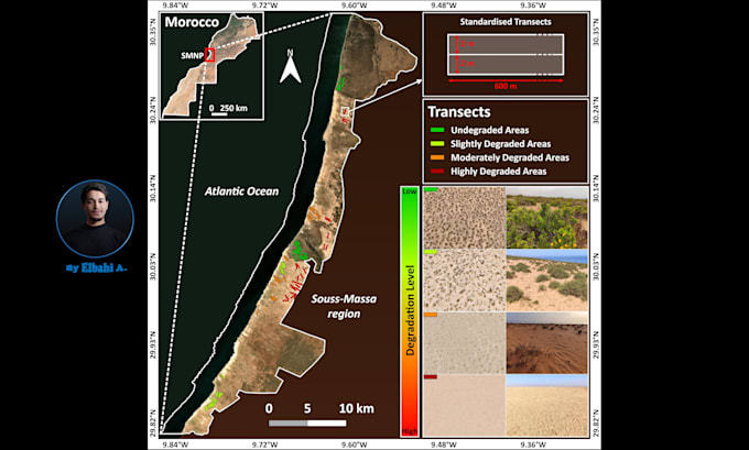
Tipos de mapas que creo: mapas de referencia y mapas temáticos - mapa coroplético, mapa de símbolos proporcionales, mapa de símbolos graduados, mapa de densidad de puntos, mapa de calor, mapa web interactivo (Leaflet), mapa infográfico, mapa de densidad, mapa físico, mapa político, mapa de isocronas (áreas alcanzables en un tiempo o distancia), mapa de tiempo de viaje, mapa de redes de carreteras/ferrocarriles, mapa catastral, mapa climático, mapa de geología, mapa de cobertura del suelo, mapa de líneas de contorno, mapa de modelos digitales de elevación, mapa satelital (imágenes Landsat, Sentinel-2, MODIS), cartograma.
Los análisis que realizo incluyen: digitalización (digitalizar datos geográficos), delineación de polígonos, análisis de proximidad (análisis de buffer), interpolación espacial, análisis de correlación, análisis temporal o detección de cambios, análisis de idoneidad (selección de sitios), análisis de terreno, conversión de formatos y georreferenciación (georeferencio mapas como mapas históricos, mapas escaneados o mapas no geoespaciales).
Los formatos en los que trabajo incluyen: GeoTIFF, Shapefile, GeoJSON, KML / KMZ, ESRI ASCII, JPEG, PNG, CSV, Microsoft Excel y muchos otros.
Por favor, discutamos el proyecto antes de que hagas un pedido.
Data Made Visual, Insights Made Clear
Level 2
Idiomas
Traducción automática
| (12) | ||
| (0) | ||
| (0) | ||
| (0) | ||
| (0) |
whitmars

Estados Unidos
Super easy to work with and professional. The process was easy, and he was understanding when I requested changes; he delivered wonderfully. I plan to come back at a later date with another project.
USD100-USD200
$
4 semanas
Tiempo

Respuesta del Freelancer

rushextreme
Cliente recurrente

Letonia
The order was completed perfectly, and very fast. Went above and beyond, the best on Fiver!
Hasta USD50
$
1 día
Tiempo
Respuesta del Freelancer

opt4text
Cliente recurrente
Estados Unidos
Elbahi A. was great, quality delivery, excellent communication, and went the extra mile with additional research and ideas. When a minor snag accrued after delivery, he adjusted immediately without hesitation. Highly recommend and will definitely use again!
Hasta USD50
$
2 días
Tiempo
Respuesta del Freelancer
coreyf08
Estados Unidos
Awesome to work with and was very flexible with the design and made all of my revision requests. Delivered ahead of schedule. Will definitely use again for any geospatial mapping needs!
Hasta USD50
$
2 días
Tiempo
Respuesta del Freelancer
rushextreme
Cliente recurrente
Letonia
Very fast and precisely what I needed.
Hasta USD50
$
1 día
Tiempo
Respuesta del Freelancer
| (12) | ||
| (0) | ||
| (0) | ||
| (0) | ||
| (0) |
whitmars
Estados Unidos
Super easy to work with and professional. The process was easy, and he was understanding when I requested changes; he delivered wonderfully. I plan to come back at a later date with another project.
USD100-USD200
$
4 semanas
Tiempo
Respuesta del Freelancer
rushextreme
Cliente recurrente
Letonia
The order was completed perfectly, and very fast. Went above and beyond, the best on Fiver!
Hasta USD50
$
1 día
Tiempo
Respuesta del Freelancer
opt4text
Cliente recurrente
Estados Unidos
Elbahi A. was great, quality delivery, excellent communication, and went the extra mile with additional research and ideas. When a minor snag accrued after delivery, he adjusted immediately without hesitation. Highly recommend and will definitely use again!
Hasta USD50
$
2 días
Tiempo
Respuesta del Freelancer
coreyf08
Estados Unidos
Awesome to work with and was very flexible with the design and made all of my revision requests. Delivered ahead of schedule. Will definitely use again for any geospatial mapping needs!
Hasta USD50
$
2 días
Tiempo
Respuesta del Freelancer
rushextreme
Cliente recurrente
Letonia
Very fast and precisely what I needed.
Hasta USD50
$
1 día
Tiempo
Respuesta del Freelancer