Explorar las categorías
Explora
Fiverr Pro
Español
$
USD


Traducción automática
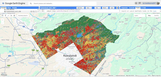
¿Necesitas mapas precisos de uso de suelo y cobertura vegetal (LULC) para tu investigación, tesis, proyecto de planificación o informe?
Me especializo en clasificación y detección de cambios LULC usando Google Earth Engine, ArcGIS Pro y imágenes satelitales (Landsat, Sentinel-2). Como graduado en Ciencias Ambientales y actualmente cursando mi maestría en GIS y Teledetección, combino habilidades técnicas sólidas con un entendimiento profundo del contexto ambiental e hidrológico detrás de los datos, para que tus mapas no solo sean visualmente correctos, sino también científicamente sólidos.
Lo que puedo entregar:
Herramientas que uso: Google Earth Engine, ArcGIS Pro, QGIS
Este servicio es ideal para estudiantes, investigadores, consultores ambientales y planificadores urbanos que necesitan datos confiables de cobertura del suelo sin la curva de aprendizaje de scripting en GEE.
Professional GIS Mapping and ArcGIS Digitization
Idiomas
Traducción automática
Traducción automática
¿Qué datos necesitas de mí?
Solo necesitas tu área de interés (shapefile, KML o un nombre de lugar/coordenadas) y el año(s) que quieres analizar.
¿Puedes usar mis propias imágenes satelitales?
Sí, si las proporcionas. De lo contrario, obtendré imágenes Landsat o Sentinel-2 de Google Earth Engine.
¿Proporcionas los archivos de datos en bruto, no solo la imagen del mapa?
Sí, los archivos shapefile y/o GeoTIFF están incluidos dependiendo del paquete.
¿Puedes hacer esto para cualquier país/región?
Sí, la cobertura satelital es global.