Explorar las categorías
Explora
Fiverr Pro
Español
$
USD

Level 2
GIS and Remote Sensing Expert
Habilidades
Revisa mis servicios
¿Quieres trabajar por horas?
Dile a Alam qué necesitas.
USD 15
/
horaGIS Engineer
Transworld Associates • Tiempo completo
May 2022 - Present • 4 yrs 2 mos
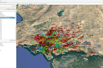
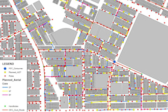
• ·Prepare High-Level Design (HLD) and Low-Level Design (LLD) for FTTH/GPON network deployment, ensuring optimal fiber distribution architecture. • ·Execute comprehensive FTTH network planning and GPON design for expansion in both greenfield and brownfield areas. • ·Develop detailed Bill of Quantities (BOQ) and Bill of Materials (BOM) for FTTH fiber infrastructure projects. • ·Create, update, and maintain detailed FTTH network diagrams, including feeder, distribution, and drop fiber layouts to support engineering and operations teams. • ·Perform georeferencing, spatial digitization, and route alignment using advanced GIS tools for accurate FTTH planning. • ·Generate KMZ/KML files for FTTH design visualization, field verification, and integration with mapping platforms. • ·Ensure accuracy, consistency, and completeness of all FTTH-related GIS datasets and technical documentation. • ·Collaborate with surveyors, planners, and project managers to align FTTH spatial designs with on-ground implementation and deployment standards
Research Associate GIS
Urban Unit, Pakistan • Tiempo completo
Apr 2022 - May 2022 • 1 mo
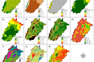
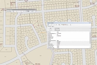
• Performed detailed cadastral mapping for land records and property using high resolution satellite imagery and GIS tools. • Collected, digitized, and organized land parcel data to support urban planning and land administration efforts. • Georeferenced paper maps and integrated them with existing geospatial datasets to ensure spatial accuracy. • Created ownership layers and attribute tables by linking cadastral data with legal and administrative records. • Conducted quality checks to verify the accuracy and completeness of spatial data. • Produced maps, reports, and visualizations to support decision-making by urban planning authorities.
GIS Analyst
National Engineering Services, Pakistan • Tiempo completo
Jul 2021 - Apr 2022 • 9 mos
• Performed cadastral mapping and analysis to support land administration and infrastructure planning projects. • Prepared and managed ownership data by integrating legal land records with spatial datasets. • Created and updated layout maps for urban and rural land development schemes. • Executed spatial queries to extract, analyze, and visualize geospatial patterns and relationships. • Conducted conversion of geospatial data between different formats. • Performed statistical analysis on geospatial datasets for project reporting, decision making, and spatial modeling.
| (28) | ||
| (2) | ||
| (0) | ||
| (0) | ||
| (0) |
aimless7

Reino Unido
Quick and accurate work, delivered exactly per the requirements. Highly recommend!
mo7amd_98

Emiratos Árabes Unidos
uwpexperts

Estados Unidos
iusckeeper
Estados Unidos
killed it! Alam delivered where others failed... go here first!
pacofdz
Cliente recurrente

México
Great with, highly recommended!!