I will do the gis mapping using the geospatial tool

A
abran333
A
abran333
Abran Idrees

Level 2

5.0
5.0
Parte de la información aparece en idioma inglés.

Acerca de este Servicio

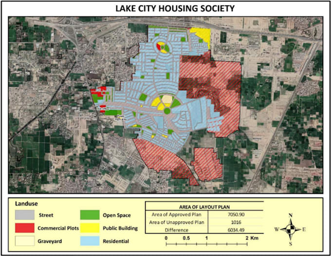
I will deliver you maps and vector data.This project was involved the creation and maintenance of digital maps that accurately depict the boundaries of individual parcels of land in ArcGIS environment. This information is often used for property assessment, taxation, land-use planning, and other related purposes.

Conoce a Abran Idrees

Abran Idrees

Data Scientist

5.0(18)

Level 2

  • DePortugal
  • Miembro desdefeb 2023
  • Responde aprox. en:1 hora
  • Última entrega1 mes
  • Idiomas

    Inglés, Portugués
Hello, Welcome to my Gig. Here is Abran Idrees. Erasmus Mundus Alumni (2022-24). Geospatial Data Scientist by profession work on multiple real-world applications using ML and DL. Also help people to get admission in top EU universities and get the remote jobs in Europe.
Reseñas

1 comentarios sobre este Servicio
5.0

(1)
(0)
(0)
(0)
(0)
Desglose de calificaciones
  • Nivel de comunicación del Freelancer
    5
  • Calidad de la entrega
    5
  • Valor de la entrega
    5
Ordenar por
Más relevante
  • K
    image-docs

    khansfaisal

    AU

    Australia

    5

    Quick response, fine work, negotiate in project.

    USD100-USD200

    $

    8 días

    Tiempo

    Útil?
    No